Showing posts with label beck. Show all posts

Tuesday, 14 May 2024

Last interglacial coast trail. Stage 6: Driffield to Burton Agnes

A light, low cloud, not even a fog in the morning. It is a bit breezy but mild. I take the 8:21 train to Driffield. As I step out of the station, I see Swifts chasing and screeching. I walk by River Head, heading east. 

The Water Forlorns, the feeder for the the Driffield Navigation.
The beautiful mills at Riverhead the beginning of Driffield Navigation.

The buried cliff follows the railway line closely and the beginning of the walk can easily follow it, a footpath by ongoing housing developments on the outskirts of Driffield. Two Roe Deer browse on the edge of a field. They look a bit shaggy, shedding their winter coat. Shortly after, at Marksman Lane, after walking by bright drifts of Red Campion, I find a herd of eight hinds and a buck on a field. It's the largest group of Roe Deer I've seen. I often see Re Deer from the train on this area, so it's nice to watch them, unbothered by my presence. A few Rabbits feed on the edge of the same field. 


The whole herd of Roe Deer.

Some of the Roe Deer appear to already have their short, reddish, summer coat, the shaggy ones keep licking their flanks, looking itchy and uncomfortable.

The sun starts breaking the clouds. Typical landscape of the Wolds.

I see a raptor and think it's a Marsh Harrier, but it banks and shows its white rump, a Hen Harrier, it promptly disappears behind the overgrown hedge and I don't see it again. 

All Saints Church.

I'm in Nafferton. Swifs chasing and Swallows. Jackdaws and busy Starlings. A lone House Martin. The imposing church, on a rise looks over the large village pond, Nafferton Mere, previously Mill Pond. A spring feeds the pond. I walk along the side street looking for gap in the houses and a clear view. The water is clear, showing many aquatic plants. There is a busking cob Mute Swan chasing the Mallards. The female is probably hidden on her nest.

Nafferton Mill Pond, looking East.

I leave the village by Lowthorpe Lane, bounded by high flowering hedges, Orange Tip males flying up and down the lane. A colony of Tree Sparrows is a nice surprise. A Whitethroat sings from an overhead cable. I spot a very distant Brown Hare on a ploughed field. It is a great day for mammals!

Young lambs by Backcarr lane.

Tree Sparrow.
Whitethroat.
Looking east towards Lowthorpe.

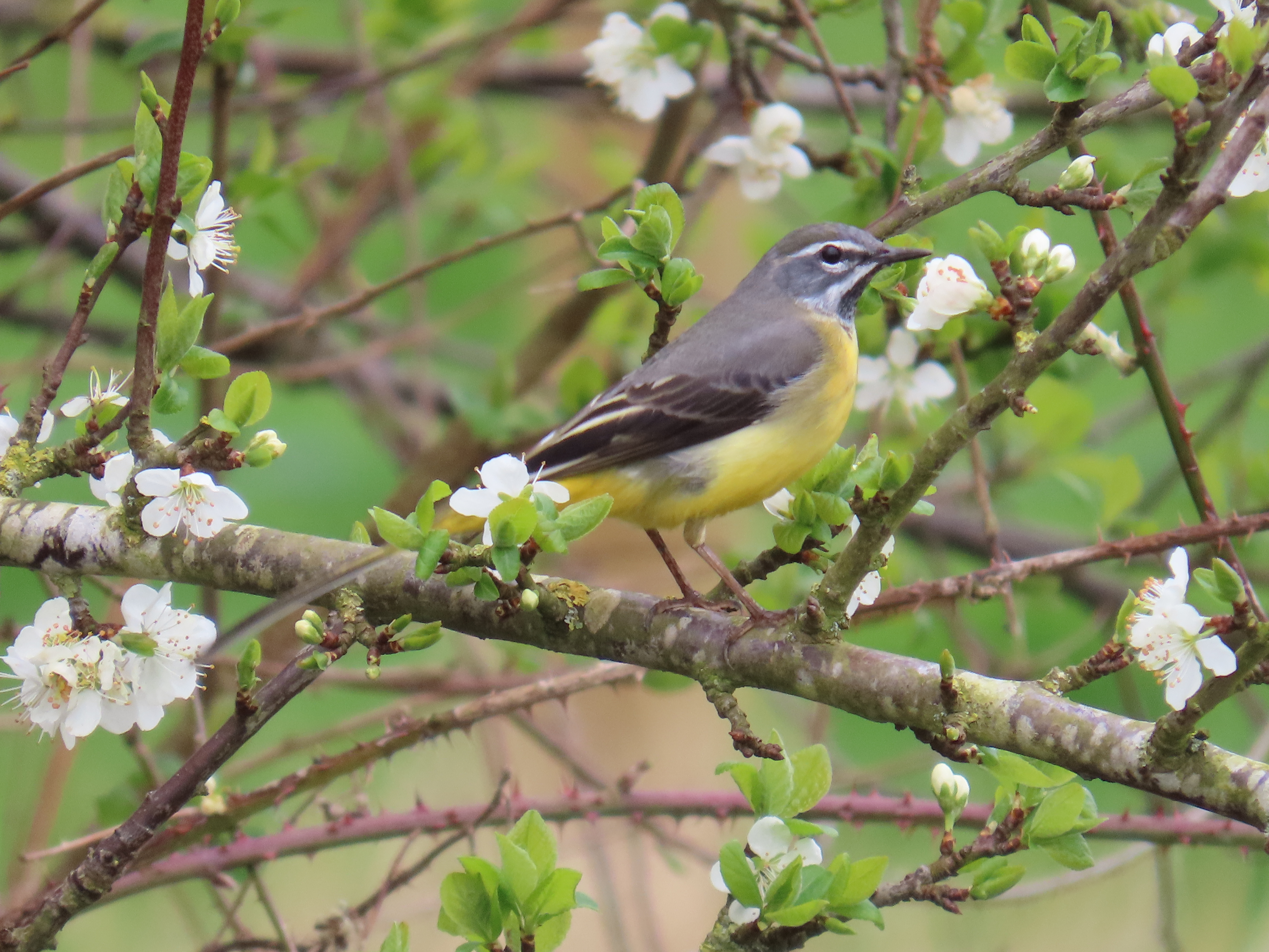
I hear a wagtail calling from a small ash. I'm underneath it but to see it, I need to get closer to it. I'm very lucky it doesn't fly away. It is a male Yellow Wagtail 'singing', my first of the year.

Yellow Wagtail.

Male Yellow Wagtail singing, the song is just a beautiful note repeated at intervals.

Lowthorpe is a small settlement with a few cottages and a church. I skirt Lowthorpe Wood and then turn north on the ridge of a small valley towards the popular picnic spot of Bracey Bridge, where I stop for my lunch. I'm a bit disappointed that so little water is visible due to trees and lush vegetation, given that there is a mill pond near the path. On the way there and back, I have a close encounter with a Brown Hare.

Lowthorpe St Martin's church.
Brown Hare.

Bracey Bridge on an old arm of the lay-by on the A614. The bridge is over Kelly Beck.
Kelly Beck with Bracey Bridge on the background.

Kelk or Kelly Beck (or Foston Beck) is a chalk stream that rises near Kilham. It flows for 16 km south, to join Frodingham Beck and then the River Hull at Emmotland, north of Tophill Low. It is a part of the River Hull Headwaters SSSI and a trout stream. Current recommended management to favour trout breeding involves annual bank vegetation cutting, introduction of woody debris, adjustable weir heights, channel narrowing and riverside woodland thinning to create high water speed and gravelly areas which are spawning sites for trout. Many of this recurrent and costly management operations could be done free of charge by a family of beavers!

Pasture by Kelly Beck.

The valley bottom, Neat Holmes, is prone to flooding, and there is a herd of cows on one side.The other side looks wilder (top shot). I stop on New Road Bridge over Kelly Beck. Again, the chalk stream has clear water with large patches of bright green water crowfoot. A family of Swans leaves the bank and swims on the beck. There are also Mallards and Moorhens and a Willow Warbler sings. I would have probably been unable to cross the valley without wellies a few weeks back judging by fresh dry mud and ruts on the lane. Brooklime leaves are covered in mud, but the new flowers shine fresh. 

Kelk or Kelly Beck.

Mute Swan female with cygnets.

I climb the shallow valley crossing Neat Holmes Wood and soon arriving at Harpham. My first Red Admiral of the year flies strong over trees. A linnet feeds young and there is another colony of Tree Sparrows. 

Barn Swallow at Harpham.

From Harpham to Burton Agnes the public footpath crosses rapeseed and wheat fields. I flush my first Yellowhammer and spot a Skylark.

The public footpath across fields to Burton Agnes.
Skylark.

I find myself with 45 minutes to spare until the next bus, so I spend some time sitting on the shade by the bank at Burton Agnes Mere. The usual wildfowl, with both Canada and Greylag with young and a grown hybrid goose. Two drake tufted ducks and a Gadwall are also residents.

Tufted Duck.

I return to the bus stop and watch the entertaining Rooks on the paddock. Young Rooks have fledged and demand being fed by their parents.
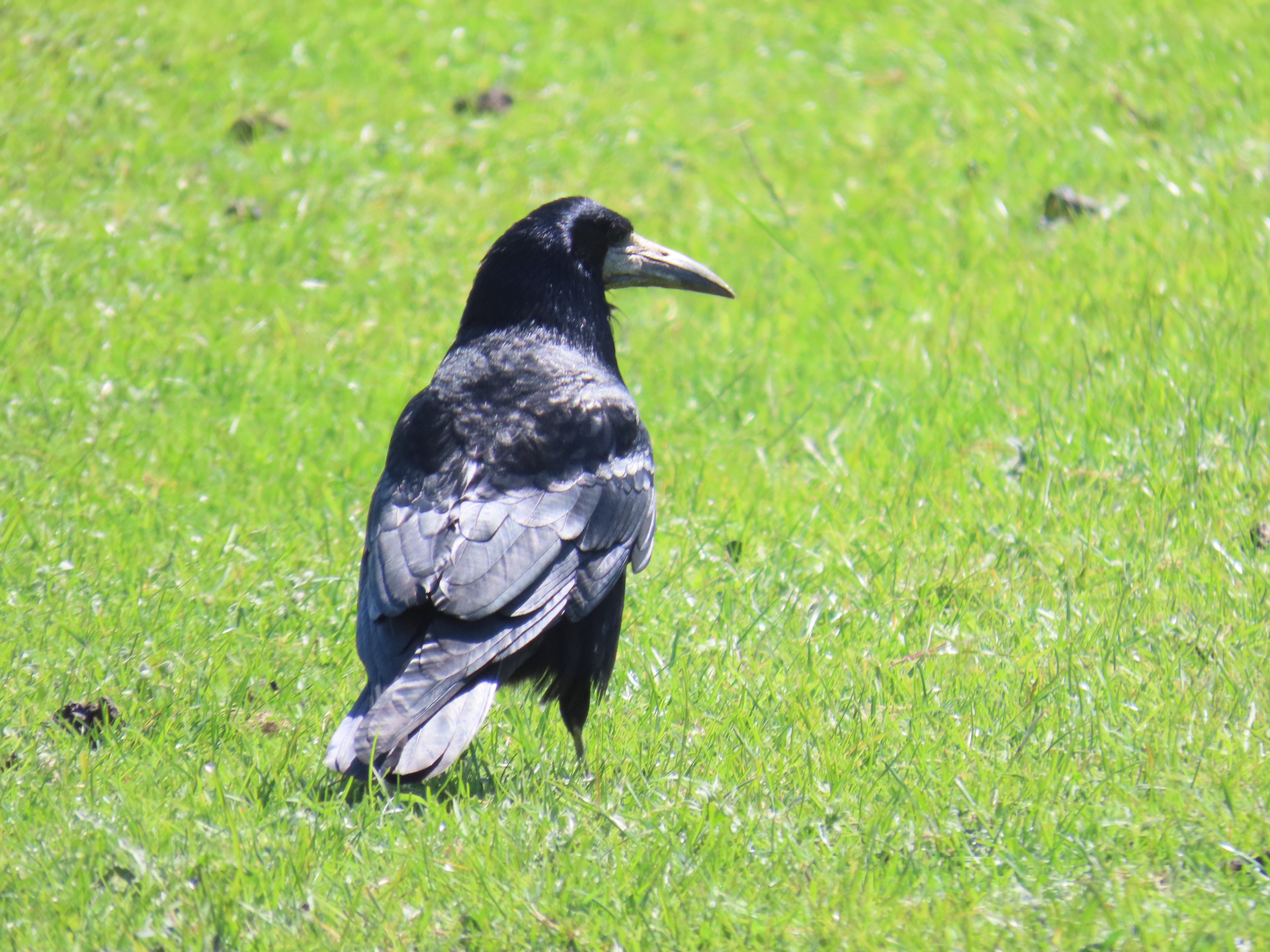
Adult Rook.
Young Rook.
Young pestering parent.
A demanding young Rook.

And what about the last interglacial? The Wolds would have certainly been wooded, but with large herds of herbivores there would have been much open grassland with trees and patches of closer woodland in places. Bison, Roe Deer, Red Deer, Aurochs and Giant Elk would have grazed and browsed the Wolds, the small Roe Deer the only remaining wild deer species in East Yorkshire. Roe Deer, which actually expanded across East Yorkshire area from the 60s and 70s, after being absent or very rare for decades due to habitat loss and poaching. Now it is a ubiquitous species, common even in suburban areas. Today's featured species though, was on the opposite side of the deer size scale...

Giant deer

The Irish Elk or Giant Elk, Megaloceros giganteus, is the largest species of deer to have ever existed. Although large numbers of complete subfossil skeletons were found in Irish peat bogs, the species was widely distributed across Europe and North Asia. Fossil remains were found at Kirkdale Cave, Victoria Cave, and at Sewerby cliff (unfortunately now lost!) demonstrating both its distribution in Yorkshire during the last interglacial, and also pointing at Cave Hyenas as their predators.

 Giant Elk from Leeds city museum.
My ink drawing of a Giant Elk stag during the rut.
Can I see them?

The Irish Elk became extinct 7000 years ago, with the last populations in the Urals of Western Russia. Their closest surviving relatives are Fallow Deer, which share their palmate antlers, and can be seen in some parks like Sewerby Hall and East Park.

Walk details. Distance: 13 km. Train to Driffield, bus 121 back from Burton Agnes to Driffield. Relatively easy terrain, with tarmac, country lanes and across arable fields. Vary little incline, with he minimum heitght is 14 m near Driffield, the maximum 25 m at Burton Agnes. There is a little cafe at Bracey Bridge for refreshments.

More information

Boylan, P. J. A new revision of the Pleistocene mammalian fauna of Kirkdale Cave, Yorkshire. Proceedings- Yorkshire Geological Society 43, 253–280 (1981).

Delany, M.J. 1985. Yorkshire Mammals. University of Bradford. 256 pp.

Lamplugh, G. W. Report on the buried cliff at Sewerby, near Bridlington. Proc. Yorks. Geol. Soc. 9, 381–392 (1887).

Monday, 25 March 2024

Last interglacial coast trail. Stage 4: Scorborough to Hutton Cranswick

Although the sky is overcast and the weather forecast threatens light showers, I get the 8:31 bus to Scorborough. It’s strange to think that Scorborough had its own beach in the last Interglacial. Now, the little village with a long history sits by a lovely beck and has an impressive church and parkland. I take a walk around the village before starting the stage proper. Scorborough Beck passes under the Driffield Road via a three arch brick bridge. There seem to be many water vole burrows, but they could be old, I see no other signs of activity. The Rooks are in full swing from their nests on large Oaks on Scorborough Park. A Great Spotted Woodpecker drums.

Scorborough Beck.
Scorborough Beck.

Two views of Scorborough Park.

Time to start walking the route. The first stage involves crossing a couple of arable fields. I check with my binoculars to aim for the yellow arrow of the public right of way, as the paths are not well trodden and there are no footprints across the crop. Skylarks sing and a pair of Red-legged Partridges run away in the distance.

Red-legged Partridges.

The route follows the Minster Way until Cawkeld Sinks. The following fields are very low-lying, with rushy springs, and squelchy to walk on. Some impressive willows lay spread on the field boundary. I get distracted and end up on the wrong side of Bryan Mills Beck. It’s quite shallow and narrow and I briefly consider taking my shoes off and just crossing it, but I end up turning round and crossing the plank bridge. Ahead, by the beck, a nervous Grey Wagtail watches me.

Rushy, wet fields with willows.
The sprawling willow.
Grey Wagtail.

At Lockington, I walk by St Mary’s church, flanked with some large yews, and follow through the village, cross a bridge over Brian Mills and as I walk along Front street, I’m delighted with its several fords (at least three!). I leave the village, and the valley of Brian Mills Beck on a quiet lane, Pit Lane with a noticeably uphill.

St Mary's Church, Lockington.
Brian Mills Beck from the bridge.
One of Lockington fords.

The route is now almost due north, by arable fields and plantations. Three Buzzards soar over Southbelt Plantation, Skylarks chase on the fields, a Yellowhammer sings from the hedge. I soon get to Kilnwick, and its beck, Kilnwick beck, which is upstream of Watton Beck valley. 

All Saints Church, Kilnwick.
Rook.
It is a broad, quite wooded valley with several streams and springs, crisscrossed with public rights of way. A bit higher up I come across Cawkeld Sinks, a lake with an island in very boggy terrain, it's a pocket of blissful wilderness. Even though today’s walk aim is to re imagine Brown Bears in the last interglacial, this area looks instead set to introduce Beavers: the lake vegetation is overgrown, with poplars laden with mistletoe, and willows, and island and fallen trees (top shot). Gadwall, Little Grebes and Moorhen are in the lake. 
Kilnwick Beck.
Gadwall.
Poplars with mistletoe.
Wood on the ground.
A boggy spring at Cawkeld Sinks.
Red Kites.
On a plantation nearby two Red Kites sit atop a spruce. The trees growing in Cawkeld chalk pit, and the wooded boggy area I just walked across make me think that it is mostly chalk pits and springs that are wooded in the midst of intensively arable land in the area: the former because the top soil was removed and there is uneven ground, which is no good for arable, therefore the vegetation has naturally colonised, the latter as they are surrounded by boggy terrain, no good for arable and too small for pasture.

I leave the Minster Way now, aiming for Hutton Cranswick. It starts to drizzle, and I’m around an hour away from Hutton Cranswick so I press on, walking by Burn Butts Farm and the evocatively named Bustard’s Nest Farm and Little Bustard Farm. As I get to Hutton Cranswick, I watch a pair of Lapwing on a field.

An extensive arable field near Bustard Nest Farm.
There used to be Great Bustards in the Wolds, maybe even on the grounds of this farm, which had the same name in the 1st edition of the OS map in 1852.
Little Bustard Farm.
Lapwing.

I get my lunch at Cranswick Farm shop. Afterwards, as I make time for the 15:04 bus, I walk to the Cranswick village pond, which will be the start of the next walk.

The village pond at Hutton Cranswick green.
There has been a lot of water in today's walk: bogs, becks, lakes and ponds. In the interglacial, the warmer climate allowed European Pond Turtle to colonise England. We can only imagine the diversity of dragonflies that would be present during this time.
Plenty of fresh molehills, rabbits (from the bus) and Roe Deer prints make the mammal list of the day.
My Brown Bear sketch.

Brown Bear

The extant Brown Bear, Ursus arctos, from the northern hemisphere was the same species that inhabited England during the Ipswichian. Unfortunately, there are few securely dated UK fossils. These include some from Barrington, Cambridge, and Cefn Caves in North Wales. A young bear jaw was reportedly found at Sewerby buried cliff, but the specimen is now lost, and that is the only East Yorkshire fossil from the Ipswichian I’ve been able to find references to. The Brown Bear needs little description, it is a large omnivore, and in the last interglacial it would have roamed across all lowland habitats, not just restricted to mountains as it is now. The Brown Bear has the broadest diet of any bear, and tends to exploit abundant, easy to find prey in an opportunistic way. It would have moved onto rivers to catch salmon during migration, it would have been at ease in woodland, to feed on acorns, beech mast and root around the woodland floor for grubs or nests, or wandered along the coast to take advantage of clams, crabs or carrion on the shoreline. Young deer or other mammals could have been predated opportunistically.

A Brown Bear skull from Creswell Crags.
Where can I see them?

Brown Bears survived in glacial times and recolonised England very quickly after the last glacial maximum suggesting that they might have persisted in the unglaciated southern England. It is unlikely that they made it in a wild state beyond Roman times in the UK, although captive individuals were imported for bear-baiting until medieval times. In mainland Europe, Brown Bear populations managed to persist in mountainous areas of South and Eastern Europe and Scandinavia and since the 60s, they have increased due to better protection and reintroductions. There is no evidence that Cave Bears, a different species, lived in the UK during the Ipswichian, but today's Brown bears have a little Cave Bear ancestry in their genomes.

Walk details. Distance: 12 km. Bus 121 to Scorborough, at 8:31. bus back from Hutton Cranswick (8 min past the hour). Some muddy paths, country lanes and arable fields. The maximum height is 42 m near Burn Butts farm, the minimum 8 m.

More information
Barnett, R. 2019. The Missing Lynx: The Past and Future of Britain’s Lost Mammals. Bloomsbury Publishing, 2019.
Barlow, A. et al. 2018. Partial genomic survival of cave bears in living brown bears. Nat Ecol Evol 2, 1563–1570 (2018).