 A beautiful sunny day with a light, cool SE wind. After arriving at Easington, I explore the grounds of the church and visit Tithe barn, a building with a thatched roof which is a scheduled ancient monument. A fox trots ahead of me at Vicar's Lane. I walk on the grassy path by the rock revetment protecting the Easington gas terminal and then move down to the beach. Heavy machinery is being used to pile large metal planks into the beach, presumably protection for the gas pipeline.
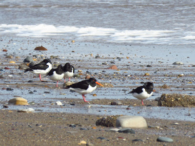
The tide is ebbing, with the low tide at 10:35, so I have plenty of time to walk on the beach, as I'm not sure if I'll be able to climb to the top of the cliff later. Checking the tides is crucial in the Holderness coast, as the high tide comes right up to the cliffs and climbing is not always possible. The beach is wide and walking is easy going as the sand is firm. Several pairs of Oystercatchers roost by the tideline. A small flock of Twite fly south just over the sand, calling along.
Oystercatcher.
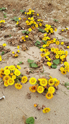
The beach is mostly sand and shingle, with towering, crumbling clay cliffs. There is nobody there, no dog walkers, no fishermen, no runners. The cliffs are at their highest at Dimlington High Land, but here they appear particularly prone to erosion, they are not vertical, but the clay is slumped in irregular patterns, forming a slope: at the base of the cliffs, flows of liquefying clay have recently poured onto the sand. It is an otherworldly landscape, like I have escaped to Mars. Only the patches of bright yellow Coltsfoot bring me back to Earth
The area where two different colour glacial tills meet.
The mud flowed over a section of the beach left high.
Another mud flow.
The mud left after glaciers melted
Holderness was born during the last ice age, as the sheets of ice coming from the north across what now is the north sea dragged a lot of sediments, at the base and front of the ice, to an area that previously had been a shallow sea. As the ice melted and the face of the ice sheet retreated, gravel, sand and clay transported by the ice were left behind, this is known as glacial till (another name is boulder clay) and it forms the cliffs of Holderness. These soft glacial sediments form three distinct layers known as Basement, Skipsea and Withernsea tills. The oldest, and deepest is the Basement till, which formed after the previous glacial cycle, (the Wolstonian ca. 300,000-130,000 BP) is only exposed around Dimlington, at the base of the cliff or on low tides, and at Bridlington. The Skipsea (in the middle) and Withernsea (at the top) tills formed as the last glacial ice retreated, each of these coming from different areas. Each was left behind as moraines after successive surges and retreats of the glacial ice lobe. Moraines were deposited during the melt of the ice sheets that covered Holderness. Read this article on glacial till in Holderness.
A patch with sand and gravel, deposited horizontally between the clay.
A patch with sand and gravel, deposited horizontally between the clay.
Looking north towards Dimlington High Land.
The thickest deposits of glacial till are found at the Dimlington high land, where the highest clay cliffs of Holderness are found, reaching over 30.5 m OSL. This is a site of geological importance, Dimlington Cliff SSSI, as it is a key stratigraphic site, that gives name to the Dimlington stadial period in the UK, from 26,000 to 13,000 years ago. There is no trigg point marking the highest point in the cliff as it is at the edge of the cliff, the slope moving landwards. The sea deepens also deepens fast at this point, with the 10 m mark at only 600 m offshore.
Two villages were lost to rapid coastal erosion: Out Newton, of which only a farm is left, and Dimlington, of which a road name and a hill are all that is left.
Games that gulls play
There is a large mixed party of gulls loafing on the tideline. So much seems to be going on that I make a stop to watch them. The Common Gulls are chasing in the wind, going to and fro, one of them is playing drop-catch with a small object, letting it fall only a short while before catching again, other starts chasing it. Watching without binoculars it would be hard to see what's happening. It is fascinating to watch their agility on the wing and their playfulness in the wind.
Suddenly, I can see Withernsea, with its gleaming white lighthouse jutting out of the coast on the distant horizon.
Old Hive
As I reach Old Hive, a cut made by a dike outfall, the cliff is not as high, and I see dog and human footprints on the beach, so I decide to climb to the cliff top, making sure to step on previous footprints, as the clay is soft in places. I'm not sure this would have been doable on wet clay, but it is mostly dry and firm, so I first scramble up the cliff, then the dike and make it to the top. A pair of Stonechats, a Meadow Pipit and a pair of Linnets are on the rough ground by the dike. Old Hive marks the boundary mark between Easington and Holmpton, just a very long field to go. Huge chunks of this field, clearly planted this winter, have fallen onto the beach (the erosion post at Holmpton registers one of the fastest speeds of erosion at Holderness, 4.3 m per year).
Games that gulls play
There is a large mixed party of gulls loafing on the tideline. So much seems to be going on that I make a stop to watch them. The Common Gulls are chasing in the wind, going to and fro, one of them is playing drop-catch with a small object, letting it fall only a short while before catching again, other starts chasing it. Watching without binoculars it would be hard to see what's happening. It is fascinating to watch their agility on the wing and their playfulness in the wind.
Old Hive
As I reach Old Hive, a cut made by a dike outfall, the cliff is not as high, and I see dog and human footprints on the beach, so I decide to climb to the cliff top, making sure to step on previous footprints, as the clay is soft in places. I'm not sure this would have been doable on wet clay, but it is mostly dry and firm, so I first scramble up the cliff, then the dike and make it to the top. A pair of Stonechats, a Meadow Pipit and a pair of Linnets are on the rough ground by the dike. Old Hive marks the boundary mark between Easington and Holmpton, just a very long field to go. Huge chunks of this field, clearly planted this winter, have fallen onto the beach (the erosion post at Holmpton registers one of the fastest speeds of erosion at Holderness, 4.3 m per year).
A large chunk of field disappeared since the crop was planted this winter. Looking north towards Holmpton.
Rook on nest.
Holmpton
The trees of the village appear on the distance, a Buzzard calls, with rooks and gulls lazily chasing it. I get to the village and have a walk around. There are plenty of birds, a huge contrast with the deserted field. Tree Sparrows chirp from the hedges, Rooks busy on their nests.
I turn round and come down to the beach again at Old Hive, finding my footsteps on the beach. I find a lump of jurassic clay with an ammonite and bivalves, and a very nice example of armoured mud ball. Armoured mud balls result from eroded pieces of mud becoming covered with pebbles and small rocks, and then being rolled around in the sea. They tend to have elongated shapes and are very common under glacial till cliffs.
I turn round and come down to the beach again at Old Hive, finding my footsteps on the beach. I find a lump of jurassic clay with an ammonite and bivalves, and a very nice example of armoured mud ball. Armoured mud balls result from eroded pieces of mud becoming covered with pebbles and small rocks, and then being rolled around in the sea. They tend to have elongated shapes and are very common under glacial till cliffs.
Jurassic fossils.
Armoured mud ball.
A small, agile gull which is mainly a winter visitor and passage migrant, although individuals can be seen year round in the area. It is an amber listed species due to population declines in the UK. Most of the wintering individuals in the area come from Scandinavia. They have a preference for feeding on the ground, and can often be seen in flocks on grassy fields feeding on worms. The spring passage occurs during March and early April.
Walk information
16.7 km, circular. Start: Easington Church car park. Finish at Holmpton Seaside Rd. No public toilets.


 A wonderfully calm day, sunny to start with then cloudier with sunny spells, but mild and no rain. A huge flock of starlings fly over the car as we get into the car park. We arrived at the Discovery Centre when a flock of over 20 Jackdaws and some Rooks flew over south. Meadow Pipits displayed around the car park, Skylarks singing. We walked on the clifftop to Beacon Lane. A Reed Bunting is busy hawking for midges or gnats - I had never seen them catching insects- while a Linnet sings.


