Monday 25 March 2024

Last interglacial coast trail. Stage 4: Scorborough to Hutton Cranswick

Although the sky is overcast and the weather forecast threatens light showers, I get the 8:31 bus to Scorborough. It’s strange to think that Scorborough had its own beach in the last Interglacial. Now, the little village with a long history sits by a lovely beck and has an impressive church and parkland. I take a walk around the village before starting the stage proper. Scorborough Beck passes under the Driffield Road via a three arch brick bridge. There seem to be many water vole burrows, but they could be old, I see no other signs of activity. The Rooks are in full swing from their nests on large Oaks on Scorborough Park. A Great Spotted Woodpecker drums.

Scorborough Beck.
Scorborough Beck.

Two views of Scorborough Park.

Time to start walking the route. The first stage involves crossing a couple of arable fields. I check with my binoculars to aim for the yellow arrow of the public right of way, as the paths are not well trodden and there are no footprints across the crop. Skylarks sing and a pair of Red-legged Partridges run away in the distance.

Red-legged Partridges.

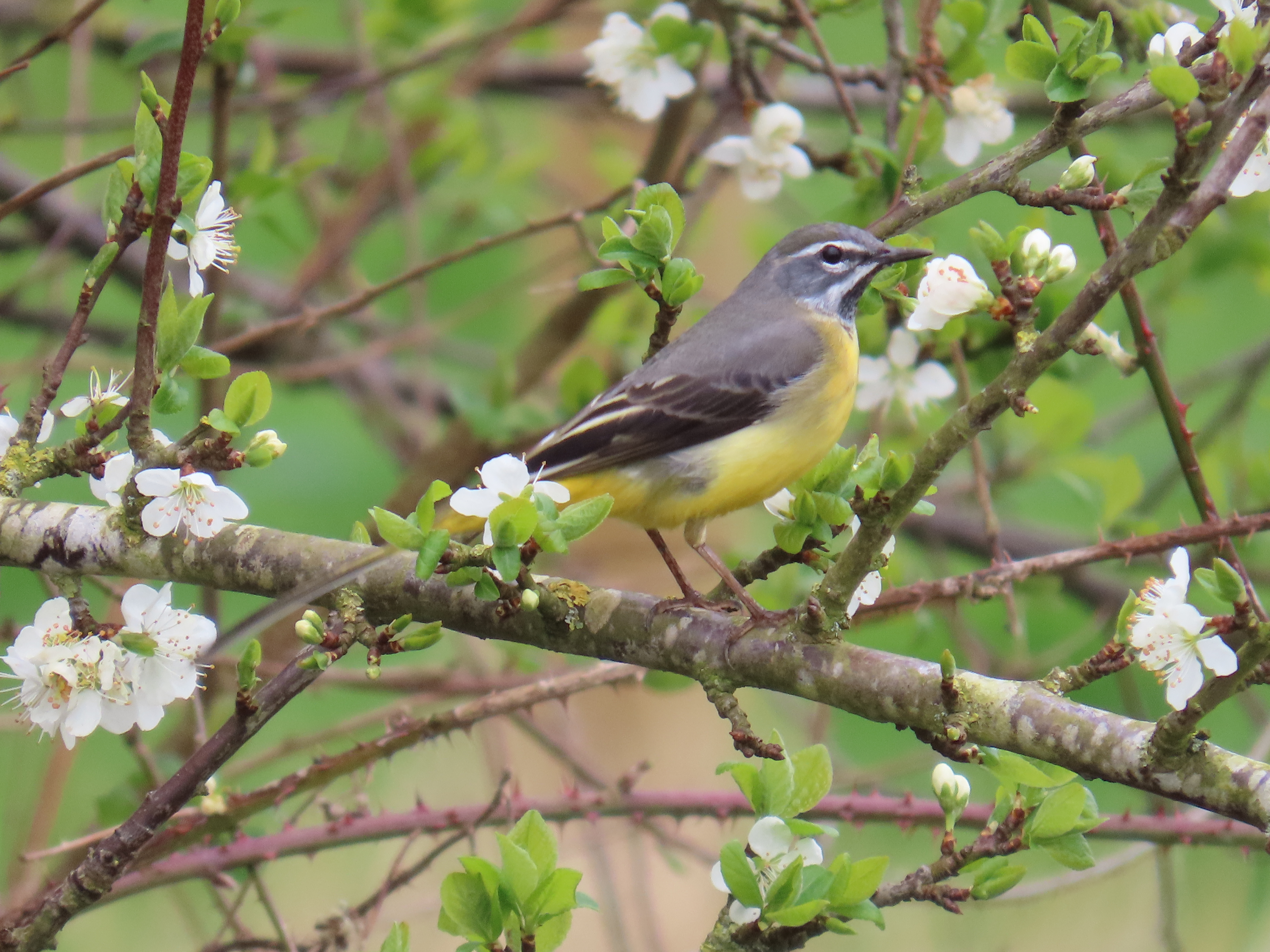
The route follows the Minster Way until Cawkeld Sinks. The following fields are very low-lying, with rushy springs, and very wet. Some impressive willows lay spread on the field boundary. I get distracted and end up on the wrong side of Bryan Mills Beck. It’s quite shallow and narrow and I briefly consider taking my shoes off and just crossing it, but I end up turning round and crossing the plank bridge. Ahead, by the beck, a nervous Grey Wagtail watches me.

Rushy, wet fields with willows.
The sprawling willow.
Grey Wagtail.

At Lockington, I walk by St Mary’s church, flanked with some large yews, and follow through the village, cross a bridge over Brian Mills and as I walk along Front street, I’m delighted with its several fords (at least three!). I leave the village, and the valley of Brian Mills Beck on a quiet lane, Pit Lane with a noticeably uphill.

St Mary's Church, Lockington.
Brian Mills Beck from the bridge.
One of Lockington fords.

The route is now almost due north, by arable fields and plantations. Three Buzzards soar over Southbelt Plantation, Skylarks chase on the fields, a Yellowhammer sings from the hedge. I soon get to Kilnwick, and its beck, Kilnwick beck, which is upstream of Watton Beck valley. 

All Saints Church, Kilnwick.
Rook.
It is a broad, quite wooded valley with several streams and springs, crisscrossed with public rights of way. A bit higher up I come across Cawkeld Sinks, a lake with an island in very boggy terrain, it's a pocket of blissful wilderness. Even though today’s walk aim is to re imagine Brown Bears in the last interglacial, this area looks instead set to introduce beavers: the lake vegetation is overgrown, with poplars laden with mistletoe, and willows, and island and fallen trees (top shot). Gadwall, Little Grebes and Moorhen are in the lake. 
Kilnwick Beck.
Gadwall.
Poplars with mistletoe.
Wood on the ground.
A boggy spring at Cawkeld Sinks.
Red Kites.
On a plantation nearby two Red Kites sit atop a spruce. The trees growing in Cawkeld chalk pit, and the wooded boggy area I just walked across make me think that it is mostly chalk pits and springs that are wooded in the midst of intensively arable land in the area: the former because the top soil was removed and there is uneven ground, which is no good for arable, therefore the vegetation has naturally colonised, the latter as they are surrounded by boggy terrain, no good for arable and too small for pasture.

I leave the Minster Way now, aiming for Hutton Cranswick. It starts to drizzle, and I’m around an hour away from Hutton Cranswick so I press on, walking by Burn Butts Farm and the evocatively named Bustard’s Nest Farm and Little Bustard Farm. As I get to Hutton Cranswick, I watch a pair of Lapwing on a field.

An extensive arable field near Bustard Nest Farm.
There used to be Great Bustards in the Wolds, maybe even in the grounds of this farm, which had the same name in the 1st edition of the OS map in 1852.
Little Bustard Farm.
Lapwing.

I get my lunch at Cranswick Farm shop. Afterwards, as I make time for the 15:04 bus, I walk to the Cranswick village pond, which will be the start of the next walk.

The village pond at Hutton Cranswick green.
There has been a lot of water in today's walk: bogs, becks, lakes and ponds. In the interglacial, the warmer climate allowed European Pond Turtle to colonise England. We can only imagine the diversity of dragonflies that would be present during this time.
Plenty of fresh molehills, rabbits from the bus and roe deer prints make the mammal count of the day.

My Brown Bear sketch.

Brown Bear

Brown Bears, Ursus arctos, the same species that inhabited England during the Ipswichian. Unfortunately there are few securely dated fossils. These include some from Barrington, Cambridge, and Cefn Caves in North Wales. A young bear jaw was reportedly found at Sewerby buried cliff, but the specimen is now lost, and that is the only East Yorkshire fossil from the Ipswichian I’ve been able to find references to. The Brown Bear needs little description, it is a large omnivore, and in the last interglacial it would have roamed across all lowland habitats, not just restricted to mountains as it is now. The Brown Bear has the broadest diet of any bear, and tends to exploit abundant, easy to find prey in an opportunistic way. It would have moved onto rivers to catch salmon during migration, it would have been at ease in woodland, to feed on acorns, beech mast and root around the woodland floor for grubs or nests, or wandered along the coast to take advantage of clams, crabs or carrion on the shoreline. Young deer or other mammals could have been predated opportunistically.

A Brown Bear skull from Creswell Crags.

Where can I see them?


Brown Bears survived in glacial times and recolonised England very quickly after the last glacial maximum suggesting that they might have persisted in southern England. It is unlikely that they made it in a wild state beyond Roman times in the UK, although captive individuals were imported for bear-baiting until medieval times. In mainland Europe, Brown Bears populations managed to persist in mountainous areas of South and Eastern Europe and Scandinavia and since the 60s, populations have increased due to better protection and reintroductions. There is no evidence that Cave Bears, a different species, lived in the UK during the Ipswichian, but today's Brown bears have a little Cave Bear ancestry in their genomes.

Walk details. Distance: 12 km. Bus 121 to Scorborough, at 8:31. bus back from Hutton Cranswick (8 min past the hour). Some muddy paths, country lanes and arable fields. The maximum height is 42 m near Burn Butts farm, the minimum 8 m.

More information
Barnett, R. 2019. The Missing Lynx: The Past and Future of Britain’s Lost Mammals. Bloomsbury Publishing, 2019.
Barlow, A. et al. 2018. Partial genomic survival of cave bears in living brown bears. Nat Ecol Evol 2, 1563–1570 (2018).

Monday 18 March 2024

Last interglacial coast trail. Stage 3: Beverley to Scorborough


I get an early bus to Flemingate, Beverley and walk to the Minster. It is a sunny, mild and still day, a Small Tortoiseshell and a Bee fly feeding on Lesser Celandines opposite the Minster. The last interglacial coastal cliff conveniently follows the centre of Beverley in an approximate north to south direction at about the 10 m over sea level. The reason for my choice of animal of the Ipswichian for today is due to the fact that Beverley is named after beavers (Anglo Saxon 'beofer lac'or ley', beaver lake or pasture). I decide to make a compilation of Beaver beaver iconography along the route. First, I walk around the Minster trying unsuccessfully to find a gargoyle depicting a beaver playing bagpipes. I ask inside and the volunteers are a bit baffled, but they helpfully point me to a small carved beaver in a book case. 

Always birds on gargoyles. This one a Stock Dove.
Jackdaw on statue.
Carved Beaver inside the Minster, on a book case.
Old Beverley Coat of arms on Beverley Market cross. It really doesn't look like a beaver!
The new rendition of the coat of arms on litter bins looks more like it.
The Beaver Pub sign.
The Beaver pub at North Bar Within.
I had never noticed this Victorian public water pump from 1860, it was beautifully reconstructed by the Beverley Civic Society.
North Bar gateway.
I thought it was a beaver on North Bar, but it looks like a squirrel.

I leave the old town through North Bar towards Molescroft following the Minster Way until the pedestrian bridge over the A1035 to join the Hudson Way.

The Minster Way is some times very narrow across Molescroft.

I'm afraid this route zig-zags quite a bit, as the most straight route by the interglacial coast is on the Driffield road, but this is a very busy road and I will avoid it, so I take the sedated Hudson Way, an abandoned railway track from Beverley to Market Weighton that is now a public footpath. Butterflies, Chiffchaffs, Yellowhammers, and Skylarks on the way. Carpets of Dog's Mercury on the banks.

Bee Fly.
Small Tortoiseshell and Comma on Blackthorn blossom.
Yellowhammer.

I leave the Hudson Way at Miles Lane, near the grounds of the abandoned Mediaeval village of Ravensthorpe, but this turns to be pretty busy too with traffic. I try an alternative route, but it turns out that it is a road to a clay-shooting ground by Bygot Wood, with scary warning signs on the trees all along not to proceed, despite it leading to a public right of way, so I have to retrace my steps. I’m glad I’m able to tick some early Wood Anemones and Ramsons at the start of the track.

A female Bullfinch was intrigued when I whistle its call.
The view north from the Hudson Way.
Miles Lane bridge over the Hudson Way.
Wood Anemones by Bygot Wood.

Ipswichian Woodland

The Anemones and Dog's Mercury are ancient woodland indicator flowers that tells us that woodland was much more extensive a few centuries ago than it is now in East Yorkshire. They remind me that you might interpret the abundance of megafauna in the last interglacial as if the British Ipswichian ecosystem was like today’s Serengeti. This is not so, the megafauna was very different in many ways (no antelopes, many deer) the flora, surprisingly, would be pretty much like the European vegetation today. We would have walked across the landscape not having much trouble recognising the trees and flowers, most species are present today. At peak interglacial conditions, the woodland was a mixed oak forest, with Pine, Birch, Elm, Oak, Maple, Hornbeam and Hazel. In the wetter areas, Alder carr would have develop. Hornbeam became more dominant in the late stages. An exotic element to the flora of the time is the presence of the Montpellier Maple, native to the Mediterranean and not found in the UK today. A strong contrast with the extremely reduced woodland cover of East Yorkshire today, just over 2%.

I skirt Leconfield following the old Driffield road and then take a footpath towards Bealey’s Beck. It's great to be back off the road. A Skylark rises and a Curlew calls, but I can't find it on the stubble of the fields. A Red Kite flies over moving up the valley, loosely chaperoned by the resident pair of Buzzards across their territory.

A spring, crystal clear water burbling from the chalky bottom. Its waters end up at Bealey's Beck.
Many flowering Primroses along the way.
I gasp when I come across the beautiful Bealey's Beck (top shot). I check the Ordnance Survey map and trace its meandering course upstream up to South Dalton, I can see the church tower spire in the horizon. The beck changes name as it progresses along its little valley from Beck's Drain, Moor Beck, Bealey's Beck and Scorborough Beck. Much of what it looks like a natural valley is open wood pasture with small plantations. The last interglacial cliff is westwards in this area, with abundant springs and streams, but it is likely a shorter stream existed back then with the higher sea level.

The simple bridge crossing of Bealey's Beck.

A Bridleway marker in the middle of a field.

Scorborough Beck by the Driffield Road. I can imagine beavers living here.

I get to the bus stop on Driffield roat at Scorborough. Sadly, a roadkilled Hedghehog is the only wild mammal I've seen today.

Beavers

Eurasian Beaver, Castor fiber, were widely distributed during the Ipswichian across England. Beavers are semi-aquatic, and live near water, not straying too far to feed. They graze aquatic plants and fell broadleaf trees to feed on the bark and leaves and to store these for the winter months. Felled trees, usually willow or aspen and birch, sprout from the stump, and this beaver coppicing means beavers have easy access to low browse forming ‘beaver pastures’. If the water is not deep, they use tree trunks and branches to build dams along rivers. Unlike other rodents, beavers form monogamous pairs that share a territory. Their young of the year (kits, often two) stay in the parental territory until they are two, so the groups is really a family of beavers. Beavers build lodges in the lake with an underwater entrance where they are safe from predators. They store vegetation inside the lodge to eat through winter and they also have their young in the safety of the lodge.They eat tree bark, twigs and leaves and also grass and aquatic vegetation. When the lake that forms behind the dam gets silted up, they form meadows, which are used by other herbivores. The beavers then move upstream and build a new dam, which forms a lake. Together with other herbivores, beavers contribute to create clearings in woodland and alongside rivers, they favour willow, which they effectively pollard so new growth is generated near the base. Beavers are regarded as ecosystem engineers and keystone species for their multiple effects on their environment and positive effects on biodiversity. Their lakes are ideal for some species of fish like pike, eel and carp, favouring slow water and the beaver meadows attract other megafauna. They slow the flow of water in the river basin. 
Beaver.
Where can I see them?
Beavers disappeared from Britain at the end of the last interglacial, when the last ice age started, but they promptly recolonised in postglacial times as trees returned to the landscape. There are many fossils in Yorkshire, including across Holderness. They appear to coexist with fisher-hunter-gatherer humans in the Mesolithic, when humans clearly benefited from the clearings created by beavers for hunting, and took advantage of their lakes for their plentiful fish. Humans are also likely to have used beaver dams as bridges and trees felled by beavers for their own purposes. Mesolithic humans even used beaver teeth and jaws as wood-working tools. It is likely beavers become extinct in East Yorkshire in the first part of the first millennium. Although there is a reintroduction program in North Yorkshire, with a family in an enclosure in Cropton Forest, it appears unlikely they will be introduced in East Yorkshire any time soon, but the little beck I visited today appears to be a suitable place.

Walk details. Distance: 15 km. Terrain: mostly flat, steep steps to negotiate bridge and two footbridges. Some sections of public rights of way muddy and a PROW section across a planted field. Maximum height 27 m. minimum 9m. Start at Beverley Minster, finish at Scorborough Driffield rd. by Scorborough Beck. The start across Beverley town, then it becomes rural with arable fields and small copses with springs and a beck.

More information

Phillips, L. Vegetational History of the Ipswichian/Eemian Interglacial in Britain and Continental Europe. New Phytol. 73, 589–604 (1974).
Coles, B.J. 2006 “Beavers in Britain’s Past” WARP Occasional Paper 19. Oxford: Oxbow. x+242 pages, 158 illustrations; ISBN 978-1-84217-2261, paperback.

Yalden, D. 2010. The History of British Mammals. Bloomsbury, 311 pp.