The River Hull drains a very flat valley, on the east bank the Holderness peninsula on the West the Wolds. It starts on chalky streams at the base of the Wolds near Driffield and runs for about 26 km and is navigable for much of its length. Today's stage runs through the old town in the city of Hull, where some of the original meandering of the river is preserved, although the river is channeled by concrete walls.
The stage started at The Deep, with a selfie with the great white shark sculpture, but today I didn't go in. Instead, I walked around the magnificent building to watch the mouth of the river Hull at Sammy's point. I didn't plan it, but I'm glad it was low tide, the fresh water of this tidal river flowing fast into the Humber Estuary. A group of Black-Headed Gulls and a few Herring Gulls washed on the shore of the mudflats.
Sammy's Point at low tide, where the river Hull from the right joins the Humber Estuary. The Humber Bridge and the Lincolnshire coast are visible in the distance.
I crossed the footbridge by The Deep to have a better look of the Deep and the Tidal Barrier, which was closed yesterday during the storm surge.
The Deep, by the mouth of the River Hull.
The Tidal Barrier.
The muddy banks of the river were peppered with Redshank footprints. A few of these waders were about, hunting for worms in the mud. A Moorhen hid behind a tuft of vegetation.
Redshank
I follow the path on the west bank of the river, walking under Myton Bridge. The path was busy with people, and I realised I had never been in it, or in the lovely Scale Lane Bridge, so I made the best of it and crossed to the other side and back again.
Scale Lane Bridge.
I was now at the back of the Museums quarter and could see the Arctic Corsair sitting on the mud, a trawler converted in a museum now moored permanently at the back of Hull and East Yorkshire Museum.
Arctic Corsair and Drypool Bridge.
A view of the garden at the back of the Wilberforce Museum.
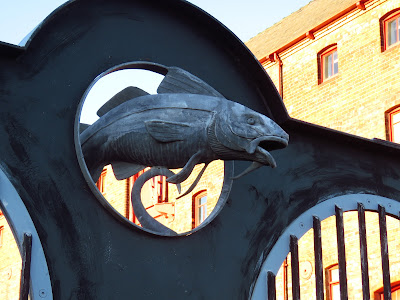
A cod sculpture by the Wilberforce Museum.
The river here is lined by steep, hard walls and in occasion wooden docks. There are dry, muddy docks and small vegetated ones that were used in the past and are now silting. This section of the river, as it bisects the city of Hull in half, is crossed by many bridges of different types, and flanked by amazing buildings and warehouses, some of them looking quite derelict, like this.
Trinity House buoy shed.
Drypool Bridge.
I crossed Drypool Bridge (a bascule bridge) to follow the footpath on the other side of the river. More Redshank, a Cormorant, a Pied Wagtail and a group of Woodpigeons.
A pair of Mallards feeding on the mud.
North Bridge, and on the right a footbridge over a dry dock.
The view downstream from North Bridge
The footpath ends at North Bridge and then it becomes hard to see the river as there is no footpath by it. I follow the winding Wilcolmlee St. on a run down industrial estate. I peep over the river at Sculcoates Bridge over Chapman Street just in time to see a Cormorant flying by.
View from Sculcoates Bridge.
Near the lovely Wilmington Bridge, now only open to pedestrians and bicycles the river becomes visible again.
Wilmington Bridge
I watched a group of gulls loafing on the river shore and a couple of cormorants fishing, I don't know how they manage as the water looks quite muddy.
Cormorant.
As I arrived at Air Street I finished my first stage on this trip. This is the route.
Bird list
- Black-Headed Gull
- Common Gull
- Herring Gull
- Crow
- Feral Pigeon
- House Sparrow
- Redshank
- Moorhen
- Mallard
- Goldfinch
- Great Tit
- Pied Wagtail
- Woodpigeon
- Wren
- Blackbird


No comments:
Post a Comment